Monitoring Drought Conditions for Wimberley, Texas and the Hill Country
Water levels affect more than just recreational activities. Keeping an eye on the water in the Wimberley area is as easy as a click of the mouse...
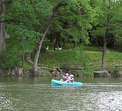
The Blanco River during a high water level period is a popular destination for residents and visitors.
Water, or the lack of water, has become an increasing concern in the western United States. Central Texas is especially vulnerable during drought conditions and this status becomes more apparent as development in the area increases.
The Wimberley Valley owes most of its beauty and attraction to the presence of a few ancient water features, including the Blanco River and Jacob's Well. More importantly, both the permanent community and visitors rely on aquifer levels that provide water for life, with the exception of a few forward-looking people who have installed rainwater harvesting systems.
When abnormally dry conditions prevail for an extended time in central Texas, as has happened for the last few years, experienced water observers raise alarms. In areas south of Austin, such as Hays County where water supplies are tied to groundwater levels, water table issues directly affect quality of life. Dry wells and the long term effects of drought conditions on flora and fauna are just two disturbing trends.
Fires are another concern for the Wimberley area, especially during drought conditions. In March 2009, a disaster declaration for Hays County was issued due to the severe drought that has had a major economic impact on the County�s agricultural producers. This declaration comes at a time when Hays and surrounding counties are also at great risk for wildfires.
Wimberley is blessed with much beauty and many natural resources. Sure, we love our hills, scenic views of rocky escarpments, fields of longhorns, shops and more. But the Blanco River, winding Hill Country creeks, and local attractions like Canyon Lake are significant reasons for most people in the Wimberley area to come or stay.
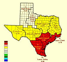
Palmer Drought Severity Index showing South Central and South Texas severe drought conditions
Perhaps it's because most of the supply of potable water is dependent upon the groundwater system feeding the Hill Country aquifers that Wimberley residents are often more sensitive to rainfall levels than some of our more metropolitan neighbors. Increased development has placed large demands on these supplies, and a disturbing trend has emerged.
Drought conditions were extreme throughout 2006. In early 2007 drought conditions for our area were rated somewhere between severe and extreme...not an enviable position. Although late spring and the first part of the summer of 2007 saw unusually large amounts of rainfall, the area was soon quickly falling back into drought conditions. At this point in 2009, most recent USGS groundwater levels are shown at "Much below normal," or "New low," in the Central Texas area. (Useful tools to assist you in monitoring where we stand concerning our most critical natural resource appear at the end of this article.)
The system below assigns a drought index number ranging from 0 to 800 that accurately describes the amount of moisture that is missing. A rating of zero defines the point where there is no moisture deficiency and 800 is the maximum drought possible.
Even with a few rainy days, the index number for the Wimberley area can remain dangerously high.
At 600, fires will burn to mineral soil. Stumps will burn to the end of underground roots and spotting will be a major problem. Fires will burn thorough the night and heavier fuels will actively burn and contribute to fire intensity.
1. Check out the fire advisories from the Texas Forest Service. Even when Wimberley is not under a burn ban, surrounding conditions can always be dangerous for wildfires. Outdoor burning should never be done without a permit and fire department notification.
2. An interactive viewer for drought tracking in Wimberley and the state. Hours of fun! Click here...
3. Water conservation is easier to practice than many of us may think. Start at the community level by joining the Wimberley Valley Watershed Association.
4. On a personal level, click here for 37 great tips about where to begin to watch the water and save big bucks.


